Prescribed Burn Along Highway 29 Corridor in Moberly Lake As Early As May 4, 2026
The Peace River Regional District is advising that the BC Wildfire Service (BCWS) and Moberly Lake Fire Department (MLFD) are conducting a prescribed burn starting as early as May 4, 2026, along the Highway 29 corridor in Moberly Lake, BC.
The operation will take place any time after 18:00hrs (6pm) MST and is expected to continue throughout the month of May 2026, depending on weather and logistics, or until the burn area is completed. This prescribed burn is for cross-training and to mitigate roadside fuels hazards such as grasses and ladder fuels.
During this time, smoke may be visible from Saulteau First Nations, Moberly Lake and to travellers along Highway 29. Residents may also observe emergency vehicles, fire personnel and operational activity in the area.
Please be assured that this operation is planned, controlled and all reasonable measures will be taken to ensure it is carried out safely.
We appreciate your patience and understanding while this important activity is completed.
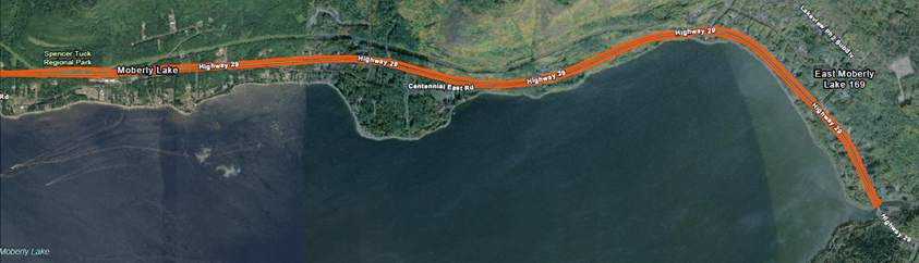
Prescribed Burn Area
The prescribed burn area is detailed below:

More Information
If you have any questions or concerns about this prescribed burn, please contact:
Chris Lirette, MLFD Fire Chief
chris.lirette@prrd.bc.ca | 250-219-8245
BC Wildfire Service
Enrico Fionda, BCWS
enrico.fionda@gov.bc.ca | 250-793-9801

Contact Us
Peace River Regional District (PRRD)
1981 Alaska Avenue,
Dawson Creek, BC
V1G 4H8
Stay Informed
Sign up to receive newsletters on important regional news and events


